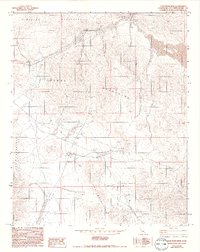
1993 Map of Camp Rock Mine
USGS Topo · Published 1993About this map
Newberry Mountains and the Rodman Mountains define this arid landscape, where industrial extraction and water management are the primary drivers of human activity. The eponymous Camp Rock Mine sits at the center of a network of prospects and open pit mines that suggest a period of intense mineral exploration. These mining operations are supported by a sparse but essential infrastructure, including a Pumping Station, Drill Hole sites, and various guzzlers designed for water collection in the desert environment.
Find a feature on this map
19 named features on this map. Tap any name to fly to it.
Don’t see what you’re looking for? This feature index may not catch every label — zoom into the map to look around manually.
Map Details
Editions of this 1993 Camp Rock Mine Map
This is the sole edition of this map. No revisions or reprints were ever made.
Other maps of this area

1953 · San Bernardino
USGS Topo · 1:250,000

1955 · Silver Bell Mine
USGS Topo · 1:24,000

1955 · Newberry
USGS Topo · 1:62,500

1955 · Ord Mountains
USGS Topo · 1:62,500

1955 · Rodman Mountains
USGS Topo · 1:62,500

1956 · San Bernardino
USGS Topo · 1:250,000

1956 · Daggett
USGS Topo · 1:62,500

1957 · San Bernardino
USGS Topo · 1:250,000

1958 · San Bernardino
USGS Topo · 1:250,000

1959 · San Bernardino
USGS Topo · 1:250,000