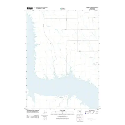
2012 Map of Campbell Creek
USGS Topo · Published 2012About this map
Lake Francis Case dominates the southern landscape of this South Dakota quadrangle, where the expansive Missouri River reservoir meets the rural uplands of Charles Mix County. The northern shore is marked by the drainage systems of Campbell Cr and Benge Cr, which carve through the terrain as they flow toward the water. A critical infrastructure link is found at the Wheeler Bridge, carrying Co Hwy 63 across the lake. The map reveals a strictly organized section-line road grid, including N Wheeler Rd and numerous numbered streets such as 291st St, reflecting the persistent agricultural footprint in the area. This 2012 survey illustrates the modern configuration of the shoreline and the transit network connecting the high plains to the water's edge.
Find a feature on this map
16 named features on this map. Tap any name to fly to it.
Don’t see what you’re looking for? This feature index may not catch every label — zoom into the map to look around manually.
Map Details
Editions of this 2012 Campbell Creek Map
This is the sole edition of this map. No revisions or reprints were ever made.
Other maps of this area

1955 · Mitchell
USGS Topo · 1:250,000

1959 · Mitchell
USGS Topo · 1:250,000

1964 · Campbell Creek
USGS Topo · 1:24,000

1964 · Whetstone Bay
USGS Topo · 1:24,000

1964 · Lake Andes NW
USGS Topo · 1:24,000

1964 · Lake Andes SW
USGS Topo · 1:24,000
1964 · South Scalp Creek
USGS Topo · 1:24,000
1964 · Bonesteel
USGS Topo · 1:24,000

1977 · Lake Andes NW
USGS Topo · 1:24,000
1977 · Lake Andes SW
USGS Topo · 1:24,000