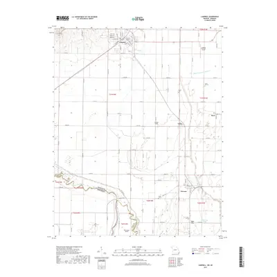
2017 Map of Campbell
USGS Topo · Published 2017About this map
The Saint Francis River snakes along the Missouri-Arkansas border in this study of southern Dunklin County, defining a landscape of intensive drainage and agricultural settlement. The city of Campbell serves as a primary hub in the north, featuring a dense street grid including N Main St and Grand Ave, while Holcomb and Pine City anchor the southern reaches. This era shows the mature development of the region's hydraulic engineering, with prominent features like Ditch Number 1 and Main Ditch District Number 17 cutting straight lines across the alluvial plain to manage the low-lying terrain. Several local burial sites, such as Gravel Hill Cem and Lynne Oak Cem, provide specific points of interest for genealogists tracing family histories in the area. Smaller communities like Gibson and Baird appear alongside the expansive Canaan Island, illustrating the dispersed yet connected nature of these Bootheel farming townships.
Find a feature on this map
92 named features on this map. Tap any name to fly to it.
Don’t see what you’re looking for? This feature index may not catch every label — zoom into the map to look around manually.
Map Details
Editions of this 2017 Campbell Map
This is the sole edition of this map. No revisions or reprints were ever made.
Other maps of this area

1940 · Malden
USGS Topo · 1:62,500

1940 · Pascola
USGS Topo · 1:62,500

1940 · Valley Ridge
USGS Topo · 1:62,500

1940 · Piggott
USGS Topo · 1:62,500

1955 · Pascola
USGS Topo · 1:62,500

1956 · Valley Ridge
USGS Topo · 1:62,500

1956 · Piggott
USGS Topo · 1:62,500

1956 · Malden
USGS Topo · 1:62,500

1956 · Dyersburg
USGS Topo · 1:250,000

1957 · Poplar Bluff
USGS Topo · 1:250,000