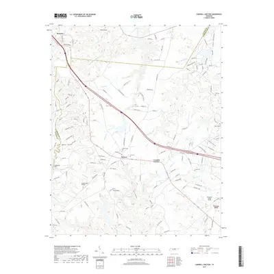
2019 Map of Campbell Junction
USGS Topo · Published 2019About this map
Monterey serves as the gateway to this portion of the Cumberland Plateau, where the rugged topography of the Verble Knobs and Verble Hollow gives way to the high, flat expanses of the plateau. The landscape is defined by the Tennessee Valley Divide, which separates the headwaters of numerous streams including Panther Cr, Clear Cr, and the Caney Fork. This 2019 survey shows the modern transportation corridors of Interstate 40 and Highway 70 bisecting the region near Mayland and Campbell Junction. Genealogists will find several well-preserved family burial sites tucked into the hills and along the ridges, such as Welch Cem, Rains Cem, and Pugh Cem. The area retains its rural character, marked by landmarks like Stillhouse Rock and Funnel Rock, even as newer developments like Westwood Blvd and Cumberland Cove Rd expand into the wooded terrain.
Find a feature on this map
139 named features on this map. Tap any name to fly to it.
Don’t see what you’re looking for? This feature index may not catch every label — zoom into the map to look around manually.
Map Details
Editions of this 2019 Campbell Junction Map
This is the sole edition of this map. No revisions or reprints were ever made.
Other maps of this area

1892 · Pikeville
USGS Topo · 1:125,000

1895 · Pikeville
USGS Topo · 1:125,000

1897 · Standingstone
USGS Topo · 1:125,000

1898 · Standingstone
USGS Topo · 1:125,000

1912 · Crossville
USGS Topo · 1:62,500

1935 · Isoline
USGS Topo · 1:24,000

1935 · Campbell Junction
USGS Topo · 1:24,000

1935 · Clarkrange
USGS Topo · 1:24,000
1936 · Crossville
USGS Topo · 1:24,000

1943 · Cookeville
USGS Topo · 1:100,000