
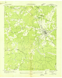
1935 Map of Campbell Junction
USGS Topo · Published 1935About this map
The Cumberland Plateau landscape is captured here in an early state-federal collaboration between the Tennessee Valley Authority and the Geological Survey. The settlement of Campbell Junction serves as the focal point for regional transportation, situated where the Tennessee Central rail corridor meets the Tennessee State Highway No 70. The map documents a critical moment of modernization as the U S Electric Power Transmission Line cuts through the terrain, illustrating the infrastructure expansion that defined this era in Tennessee history.
Find a feature on this map
20 named features on this map. Tap any name to fly to it.
Don’t see what you’re looking for? This feature index may not catch every label — zoom into the map to look around manually.
Map Details
Editions of this 1935 Campbell Junction Map
This is the sole edition of this map. No revisions or reprints were ever made.
Other maps of this area

1892 · Pikeville
USGS Topo · 1:125,000

1895 · Pikeville
USGS Topo · 1:125,000

1897 · Standingstone
USGS Topo · 1:125,000

1898 · Standingstone
USGS Topo · 1:125,000

1912 · Crossville
USGS Topo · 1:62,500

1935 · Isoline
USGS Topo · 1:24,000

1935 · Clarkrange
USGS Topo · 1:24,000
1936 · Crossville
USGS Topo · 1:24,000

1943 · Cookeville
USGS Topo · 1:100,000

1944 · Cookeville
USGS Topo · 1:100,000