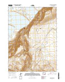
2017 Map of Campbell Lake
USGS Topo · Published 2017About this map
Poker Jim Ridge dominates the central topography of this Lake County region, where the high desert terrain transitions into a complex system of seasonal lakes and springs. Water management and natural catchment define the landscape, as seen in the positioning of Hilltop Reservoir and Paiute Reservoir. The map documents a sparse but vital network of water sources, including Stone Corral Lake, Petroglyph Lake, and the named Hot Springs and Inlet Spring at the southern edge.
Find a feature on this map
20 named features on this map. Tap any name to fly to it.
Don’t see what you’re looking for? This feature index may not catch every label — zoom into the map to look around manually.
Map Details
Editions of this 2017 Campbell Lake Map
This is the sole edition of this map. No revisions or reprints were ever made.
Other maps of this area

1955 · Adel
USGS Topo · 1:250,000

1957 · Adel
USGS Topo · 1:250,000

1958 · Adel
USGS Topo · 1:250,000

1962 · Adel
USGS Topo · 1:250,000

1966 · Bluejoint Lake East
USGS Topo · 1:24,000

1966 · Rabbit Hills NE
USGS Topo · 1:24,000

1967 · Flagstaff Lake
USGS Topo · 1:24,000

1967 · Campbell Lake
USGS Topo · 1:24,000

1967 · Flook Lake
USGS Topo · 1:24,000

1967 · Bluejoint Lake West
USGS Topo · 1:24,000