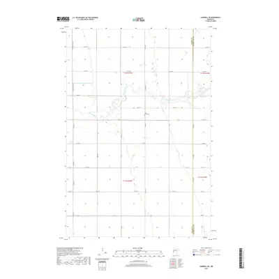
2019 Map of Campbell NE
USGS Topo · Published 2019About this map
The Otter Tail River meanders across this landscape on the border of Wilkin and Otter Tail counties, defining much of the local geography. This rural region is characterized by a deliberate system of agricultural drainage and transportation, evidenced by the presence of Co-operative Ditch Number One and a rigid grid of county roads and townships. The Vukku Church Cem serves as a central landmark for local history, representing the enduring presence of the area's early congregations. The map records the precise boundary lines of Wilkin Co Otter Tail Co alongside township markers like t132n r45w and t131n r44w. This late-decade survey details the modern layout of rural infrastructure, including Co Hwy 162 and Co Rd 160, which connect the scattered farmsteads across the fertile western plains of Minnesota.
Find a feature on this map
24 named features on this map. Tap any name to fly to it.
Don’t see what you’re looking for? This feature index may not catch every label — zoom into the map to look around manually.
Map Details
Editions of this 2019 Campbell NE Map
This is the sole edition of this map. No revisions or reprints were ever made.
Other maps of this area

1910 · Wendell
USGS Topo · 1:62,500

1913 · Fergus Falls
USGS Topo · 1:62,500

1913 · Wendell
USGS Topo · 1:62,500

1919 · Rothsay
USGS Topo · 1:62,500

1951 · Rothsay
USGS Topo · 1:62,500

1951 · Campbell
USGS Topo · 1:62,500

1953 · Fargo
USGS Topo · 1:250,000

1956 · Fargo
USGS Topo · 1:250,000

1966 · Carlisle
USGS Topo · 1:24,000
1973 · Stony Lake
USGS Topo · 1:24,000