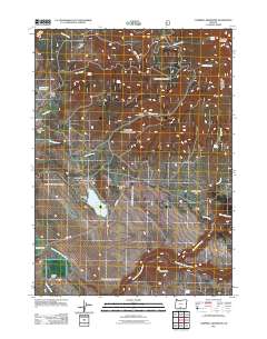
2011 Map of Campbell Reservoir
USGS Topo · Published 2011About this map
Seven C Ranch and a network of high-elevation flats define this pocket of the Oregon Cascades in the early 21st century. The landscape is characterized by its complex hydrology, with the South Fork Sprague River and Brownsworth Creek draining the southern slopes below Round Butte. The central portion of the map is dominated by the Campbell Reservoir, held by the Campbell Dam, serving as a critical water management point in this arid timber and ranching country.
Find a feature on this map
32 named features on this map. Tap any name to fly to it.
Don’t see what you’re looking for? This feature index may not catch every label — zoom into the map to look around manually.
Map Details
Editions of this 2011 Campbell Reservoir Map
This is the sole edition of this map. No revisions or reprints were ever made.
Other maps of this area

1889 · Klamath
USGS Topo · 1:250,000

1894 · Klamath
USGS Topo · 1:250,000

1955 · Klamath Falls
USGS Topo · 1:250,000

1958 · Klamath Falls
USGS Topo · 1:250,000

1960 · Riverbed Butte
USGS Topo · 1:62,500

1960 · Bly
USGS Topo · 1:62,500

1960 · Fishhole Mtn
USGS Topo · 1:62,500

1966 · Sandhill Crossing
USGS Topo · 1:24,000

1966 · Lee Thomas Crossing
USGS Topo · 1:24,000

1974 · Lake Abert
USGS Topo · 1:100,000