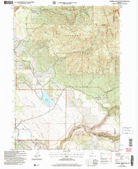
2004 Map of Campbell Reservoir
USGS Topo · Published 2007About this map
Campbell Reservoir dominates the low-lying terrain of south-central Oregon in this 2004 revision, situated where the high desert flats meet the rising timber of the Fremont National Forest. The landscape is a study in transition between open grazing lands and protected wilderness, anchored by the volcanic prominence of Gearhart Mountain and the Gearhart Mountain Wilderness. Water management is central to the area's utility, with features like Obenchain Reservoir and numerous springs such as Whisky Spring and Buzz Spring sustaining the livestock operations that utilize the extensive system of flats, including Yaden Flat and Dutchman Flat.
Find a feature on this map
49 named features on this map. Tap any name to fly to it.
Don’t see what you’re looking for? This feature index may not catch every label — zoom into the map to look around manually.
Map Details
Editions of this 2004 Campbell Reservoir Map
This is the sole edition of this map. No revisions or reprints were ever made.
Other maps of this area

1889 · Klamath
USGS Topo · 1:250,000

1894 · Klamath
USGS Topo · 1:250,000

1955 · Klamath Falls
USGS Topo · 1:250,000

1958 · Klamath Falls
USGS Topo · 1:250,000

1960 · Riverbed Butte
USGS Topo · 1:62,500

1960 · Bly
USGS Topo · 1:62,500

1960 · Fishhole Mtn
USGS Topo · 1:62,500

1966 · Sandhill Crossing
USGS Topo · 1:24,000

1966 · Lee Thomas Crossing
USGS Topo · 1:24,000

1974 · Lake Abert
USGS Topo · 1:100,000