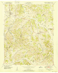
1951 Map of Campbells Station
USGS Topo · Published 1951About this map
Culleoka sits at the northern edge of this mid-century survey, where the Louisville and Nashville railroad winds through the hill country of Maury, Marshall, and Giles counties. The landscape is defined by the steep terrain of Elk Ridge and the Devils Backbone, creating a complex network of hollows like Sheepneck Hollow and Happy Hollow. These narrow valleys hosted small farming communities and numerous family burial grounds, including the Ballanfant Cem and Amis Cem near the Mooresville Pike.
Find a feature on this map
81 named features on this map. Tap any name to fly to it.
Don’t see what you’re looking for? This feature index may not catch every label — zoom into the map to look around manually.
Map Details
Editions of this 1951 Campbells Station Map
3 editions found
Other maps of this area

1901 · Colombia
USGS Topo · 1:125,000

1936 · Milky Way
USGS Topo · 1:24,000

1936 · Cornersville
USGS Topo · 1:24,000

1936 · Lewisburg
USGS Topo · 1:24,000

1936 · Brick Church
USGS Topo · 1:24,000

1936 · Verona
USGS Topo · 1:24,000

1936 · Campbells Station
USGS Topo · 1:24,000

1936 · Glendale
USGS Topo · 1:24,000

1936 · Columbia
USGS Topo · 1:24,000

1936 · Lynnville
USGS Topo · 1:24,000