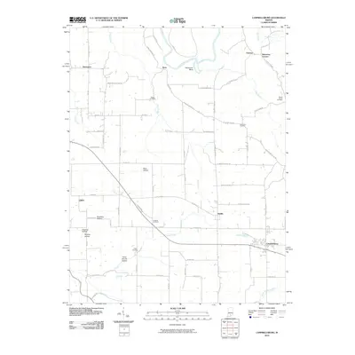
2010 Map of Campbellsburg
USGS Topo · Published 2010About this map
Campbellsburg and Saltillo anchor the southeastern portion of this landscape, where the local terrain is defined by a network of hollows and watercourses. The path of Carters Creek and the Lost River carve through the southern sections, while the north is shaped by the wide Horseshoe Bend of the East Fork White River. This area is characterized by scattered settlements like Bono and Brimstone Corners, connected by a web of rural routes such as W Saltillo Bono Rd and Tunnelton Bono Rd. Genealogists will find a high concentration of burial sites across the quadrangle, including the Talbott Cemetery, Freedom Cemetery, and Freed Cemetery, which serve as markers of the long-standing agricultural communities in this part of Indiana. The western edge is dotted with distinctive topographic features like Bane Hollow and Shantaky Hollow, illustrating the diverse elevations that influenced early land use and road placement.
Find a feature on this map
72 named features on this map. Tap any name to fly to it.
Don’t see what you’re looking for? This feature index may not catch every label — zoom into the map to look around manually.
Map Details
Editions of this 2010 Campbellsburg Map
This is the sole edition of this map. No revisions or reprints were ever made.
Other maps of this area

1934 · Bedford
USGS Topo · 1:48,000

1937 · Bedford
USGS Topo · 1:62,500

1950 · Becks Mill
USGS Topo · 1:24,000

1950 · Mitchell
USGS Topo · 1:24,000

1951 · Smedley
USGS Topo · 1:24,000

1956 · Vincennes
USGS Topo · 1:250,000

1957 · Vincennes
USGS Topo · 1:250,000

1957 · Campbellsburg
USGS Topo · 1:24,000

1957 · Livonia
USGS Topo · 1:24,000
1957 · Paoli
USGS Topo · 1:24,000