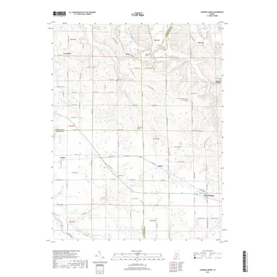
2019 Map of Campbellsburg
USGS Topo · Published 2019About this map
The East Fork White River carves a winding path through the northern reach of this landscape, creating the prominent Horseshoe Bend near the settlement of Bono. This portion of Indiana, where Lawrence, Orange, and Washington counties meet, is characterized by the broad Mitchell Plain and a network of watercourses including Sugar Creek, Clifty Creek, and Carters Cr. The map captures the distinct spatial relationship between several small rural communities, from the larger hub of Campbellsburg in the southeast to Saltillo, Leipsic, and Stonington. Genealogists will find significant value in the distribution of family and community burial sites across the township lines, such as Freedom Cem, Talbott Cem, and New Hope Cem. The transition from the river bluffs to the flatter plains is marked by a dense grid of rural routes like Bono Rd and Cave River Valley Rd, reflecting the long-established agricultural and residential patterns of the region.
Find a feature on this map
113 named features on this map. Tap any name to fly to it.
Don’t see what you’re looking for? This feature index may not catch every label — zoom into the map to look around manually.
Map Details
Editions of this 2019 Campbellsburg Map
This is the sole edition of this map. No revisions or reprints were ever made.
Other maps of this area

1934 · Bedford
USGS Topo · 1:48,000

1937 · Bedford
USGS Topo · 1:62,500

1950 · Becks Mill
USGS Topo · 1:24,000

1950 · Mitchell
USGS Topo · 1:24,000

1951 · Smedley
USGS Topo · 1:24,000

1956 · Vincennes
USGS Topo · 1:250,000

1957 · Vincennes
USGS Topo · 1:250,000

1957 · Campbellsburg
USGS Topo · 1:24,000

1957 · Livonia
USGS Topo · 1:24,000
1957 · Paoli
USGS Topo · 1:24,000