
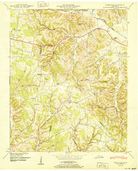
1936 Map of Campbellsville
USGS Topo · Published 1936About this map
The community of Campbellsville anchors this mid-1930s landscape, positioned at the edge of a rural network defined by its church congregations and school districts. The map documents a deeply established social geography, where rural life revolved around local landmarks like Mt Horeb Ch and Marcella Falls Ch. Genealogists will find significant value in the distribution of family-named burial grounds, including Yarbrough Cem, Kimbrough Cem, and Carter Cem, which provide a geographic record of the families settled along the county line.
Find a feature on this map
55 named features on this map. Tap any name to fly to it.
Don’t see what you’re looking for? This feature index may not catch every label — zoom into the map to look around manually.
Map Details
Editions of this 1936 Campbellsville Map
This is the sole edition of this map. No revisions or reprints were ever made.
Other maps of this area

1936 · Sandy Hook
USGS Topo · 1:24,000

1936 · Milky Way
USGS Topo · 1:24,000

1936 · Lawrenceburg
USGS Topo · 1:24,000

1936 · Ethridge
USGS Topo · 1:24,000

1936 · Pulaski
USGS Topo · 1:24,000

1936 · Crestview
USGS Topo · 1:24,000

1936 · Bodenham
USGS Topo · 1:24,000

1936 · Lynnville
USGS Topo · 1:24,000

1948 · Bodenham
USGS Topo · 1:24,000
1950 · Bodenham
USGS Topo · 1:24,000