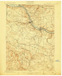
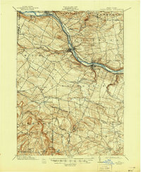
1902 Map of Canajoharie
USGS Topo · Published 1915About this map
The Mohawk River corridor serves as the industrial and transportation backbone of this central New York landscape at the turn of the century. The dual presence of the Erie Canal and competing rail lines, specifically the New York Central and Hudson River RR and the West Shore RR, illustrates the intense transit activity through the valley. Major settlements like Canajoharie, Ft. Plain, and St. Johnsville are clustered tightly along these water and rail arteries, while the upland plateaus to the north and south reveal a network of smaller farming communities and hamlets such as Stone Arabia and Freysbush. To the south, the terrain rises toward Sharon Springs, a noted destination where the landscape shifts from the riverine flats of Palatine Bridge to more dissected hills. The map captures a transitional moment for the Mohawk Valley, showing established village centers and the historical Palatine Church amidst a densely settled rural interior.
Find a feature on this map
59 named features on this map. Tap any name to fly to it.
Don’t see what you’re looking for? This feature index may not catch every label — zoom into the map to look around manually.
Map Details
Editions of this 1902 Canajoharie Map
6 editions found
Other maps of this area

1896 · Fonda
USGS Topo · 1:62,500

1898 · Fonda
USGS Topo · 1:62,500

1898 · Canajoharie
USGS Topo · 1:62,500

1898 · Schoharie
USGS Topo · 1:62,500

1900 · Little Falls
USGS Topo · 1:62,500

1900 · Canajoharie
USGS Topo · 1:62,500

1900 · Schoharie
USGS Topo · 1:62,500

1901 · Lassellsville
USGS Topo · 1:62,500

1902 · Canajoharie
USGS Topo · 1:62,500

1902 · Fonda
USGS Topo · 1:62,500