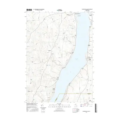
2016 Map of Canandaigua Lake
USGS Topo · Published 2016About this map
Canandaigua and the western shores of its namesake lake define this section of the Finger Lakes region. The landscape is characterized by a series of dramatic lakefront points and deeply cut ravines, including Tichenor Gully, Barnes Gully, and Seneca Point Gully. Small lakeside communities like Cottage City and Crystal Beach occupy the eastern shore, while the interior is marked by the agricultural hamlet of Cheshire. This 2016 survey captures the area's mix of residential development and preserved heritage, seen in the numerous family cemeteries such as Pine Bank Cem and Wheeler Cem. The map provides detailed coastal geography, naming features from Squaw Island in the north to the prominent elevation of Bare Hill near the southern boundary of the quadrangle.
Find a feature on this map
100 named features on this map. Tap any name to fly to it.
Don’t see what you’re looking for? This feature index may not catch every label — zoom into the map to look around manually.
Map Details
Editions of this 2016 Canandaigua Lake Map
This is the sole edition of this map. No revisions or reprints were ever made.
Other maps of this area

1900 · Naples
USGS Topo · 1:62,500

1900 · Canandaigua
USGS Topo · 1:62,500

1902 · Phelps
USGS Topo · 1:62,500

1903 · Naples
USGS Topo · 1:62,500

1903 · Canandaigua
USGS Topo · 1:62,500

1903 · Penn Yan
USGS Topo · 1:62,500

1913 · Naples
USGS Topo · 1:62,500
1942 · Victor
USGS Topo · 1:31,680
1942 · Bristol Springs
USGS Topo · 1:31,680

1942 · Middlesex
USGS Topo · 1:31,680