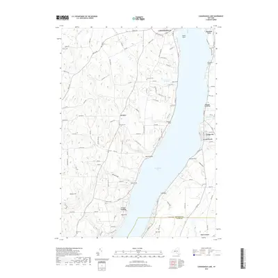
2019 Map of Canandaigua Lake
USGS Topo · Published 2019About this map
Canandaigua Lake dominates this Finger Lakes landscape, where deep glacial gullies like Barnes Gully and Fisher Gully cut through the western uplands toward the water. The settlement of Cheshire serves as a central hub for the rural interior, surrounded by a high density of family and community burial grounds including Pine Bank Cem, Lucas Cem, and the Hurn Memorial Cem. Along the western shoreline, prominent points such as Menteth Point and Tichenor Point define the lake’s edge, while the eastern shore is marked by more concentrated residential developments like Cottage City and Crystal Beach. The topography rises sharply toward Bare Hill in the south and Johnson Hill to the west, illustrating the dramatic elevation changes that characterize the region. Further north, the city of Canandaigua transitions from its historic center toward the recreational grounds of Roseland Park and the unique landmark of Squaw Island.
Find a feature on this map
89 named features on this map. Tap any name to fly to it.
Don’t see what you’re looking for? This feature index may not catch every label — zoom into the map to look around manually.
Map Details
Editions of this 2019 Canandaigua Lake Map
This is the sole edition of this map. No revisions or reprints were ever made.
Other maps of this area

1900 · Naples
USGS Topo · 1:62,500

1900 · Canandaigua
USGS Topo · 1:62,500

1902 · Phelps
USGS Topo · 1:62,500

1903 · Naples
USGS Topo · 1:62,500

1903 · Canandaigua
USGS Topo · 1:62,500

1903 · Penn Yan
USGS Topo · 1:62,500

1913 · Naples
USGS Topo · 1:62,500
1942 · Victor
USGS Topo · 1:31,680
1942 · Bristol Springs
USGS Topo · 1:31,680

1942 · Middlesex
USGS Topo · 1:31,680