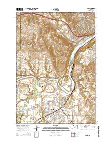
2014 Map of Canby
USGS Topo · Published 2014About this map
The Willamette River and its major tributaries, the Molalla River and Tualatin River, converge in this Clackamas County landscape, creating a complex network of waterways and landings. The river-oriented infrastructure is evident in the multiple crossings and recreation points such as the Canby Ferry Landing North and the Bernert Landing Boat Ramp. Notable settlements include the city of Canby, the historic town of Barlow, and the residential areas of West Linn and Oregon City.
Find a feature on this map
85 named features on this map. Tap any name to fly to it.
Don’t see what you’re looking for? This feature index may not catch every label — zoom into the map to look around manually.
Map Details
Editions of this 2014 Canby Map
This is the sole edition of this map. No revisions or reprints were ever made.
Other maps of this area

1914 · Oregon City
USGS Topo · 1:62,500

1916 · Tualatin
USGS Topo · 1:62,500

1923 · Mount Angel
USGS Topo · 1:62,500

1939 · Molalla
USGS Topo · 1:62,500

1939 · Oregon City
USGS Topo · 1:62,500

1939 · Tualatin
USGS Topo · 1:62,500

1940 · Tualatin
USGS Topo · 1:62,500

1940 · Molalla
USGS Topo · 1:62,500

1940 · Mount Angel
USGS Topo · 1:62,500

1941 · Oregon City
USGS Topo · 1:62,500