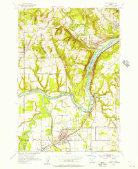
1954 Map of Canby
USGS Topo · Published 1957About this map
The Willamette River carves a deep, winding path through this mid-1950s landscape, serving as the primary geographic anchor for established communities like Willamette and Canby. The convergence of the Mollala River, Pudding River, and Tualatin River highlights a region defined by its complex waterways and fertile valleys. While Canby serves as a hub with its County Fairgrounds and High Sch, the surrounding area is dotted with small-scale agricultural landmarks such as Tualatin Grange and Warner Grange. Transportation and industry follow the terrain, with the Southern Pacific tracks and Pacific Highway East paralleling the riverbanks. Local history is deeply embedded in the many named burial grounds, including Robert Bird Cemetery and Zoar Cemetery, which mark the early homesteads of the north Willamette Valley.
Find a feature on this map
53 named features on this map. Tap any name to fly to it.
Don’t see what you’re looking for? This feature index may not catch every label — zoom into the map to look around manually.
Map Details
Editions of this 1954 Canby Map
This is the sole edition of this map. No revisions or reprints were ever made.
Other maps of this area

1914 · Oregon City
USGS Topo · 1:62,500

1916 · Tualatin
USGS Topo · 1:62,500

1923 · Mount Angel
USGS Topo · 1:62,500

1939 · Molalla
USGS Topo · 1:62,500

1939 · Oregon City
USGS Topo · 1:62,500

1939 · Tualatin
USGS Topo · 1:62,500

1940 · Tualatin
USGS Topo · 1:62,500

1940 · Molalla
USGS Topo · 1:62,500

1940 · Mount Angel
USGS Topo · 1:62,500

1941 · Oregon City
USGS Topo · 1:62,500