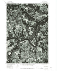
1975 Map of Canby
USGS Topo · Published 1977About this map
The confluence of major waterways and the expansion of mid-valley settlements define this 1975 orthophotoquad. The Willamette River curves sharply through the center of the sheet, joined from the north by the Tualatin River. This aerial perspective shows Canby as a developing hub of residential blocks and agriculture, while to the north, the communities of West Linn and Sunset occupy the higher ground near the river's bend. The landscape transition from the structured orchards and fields surrounding Canby to the suburban growth near the larger rivers is clearly visible. This document is an orthophotograph produced in cooperation with the Soil Conservation Service, offering a precise visual record of land use and timber cover in Clackamas County during the mid-1970s.
Find a feature on this map
5 named features on this map. Tap any name to fly to it.
Don’t see what you’re looking for? This feature index may not catch every label — zoom into the map to look around manually.
Map Details
Editions of this 1975 Canby Map
This is the sole edition of this map. No revisions or reprints were ever made.
Other maps of this area

1914 · Oregon City
USGS Topo · 1:62,500

1916 · Tualatin
USGS Topo · 1:62,500

1923 · Mount Angel
USGS Topo · 1:62,500

1939 · Molalla
USGS Topo · 1:62,500

1939 · Oregon City
USGS Topo · 1:62,500

1939 · Tualatin
USGS Topo · 1:62,500

1940 · Tualatin
USGS Topo · 1:62,500

1940 · Molalla
USGS Topo · 1:62,500

1940 · Mount Angel
USGS Topo · 1:62,500

1941 · Oregon City
USGS Topo · 1:62,500