
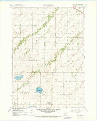
1967 Map of Canby
USGS Topo · Published 1968About this map
Canby serves as the primary hub of this southwestern Minnesota landscape, situated at the intersection of the Chicago and North Western railroad and local trade routes. The town is well-established with civic infrastructure including the Vocational Sch, County Fairground, and the recreational Lake Sylvan Park. Beyond the town limits, the geography is defined by the drainage basins of the Lac qui Parle River and Canby Creek, which cut through the agricultural townships of Fortier, Norman, and Hammer. To the northwest, the small settlement of Burr sits along the rail line near the headwaters of Lazarus Creek. The map provides significant genealogical value through its numerous rural burial sites, such as St Peters Cem, Trinity Cem, and Swenson Cem, which often represent the early pioneer congregations of these prairie townships.
Find a feature on this map
28 named features on this map. Tap any name to fly to it.
Don’t see what you’re looking for? This feature index may not catch every label — zoom into the map to look around manually.
Map Details
Editions of this 1967 Canby Map
This is the sole edition of this map. No revisions or reprints were ever made.
Other maps of this area

1953 · Watertown
USGS Topo · 1:250,000

1958 · Watertown
USGS Topo · 1:250,000

1967 · Dawson SW
USGS Topo · 1:24,000

1967 · Gary
USGS Topo · 1:24,000

1967 · Canby NW
USGS Topo · 1:24,000

1967 · Porter
USGS Topo · 1:24,000
1967 · Porter SW
USGS Topo · 1:24,000

1967 · Gary SE
USGS Topo · 1:24,000

1967 · Canby SE
USGS Topo · 1:24,000

1967 · Hendricks
USGS Topo · 1:24,000