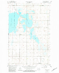
1957 Map of Cando SE
USGS Topo · Published 1984About this map
Lake Alice and its surrounding wetlands dominate this prairie landscape in Ramsey County and Towner County, reflecting the region's vital role in the central flyway. The establishment of the Lake Alice National Wildlife Refuge underscores the conservation efforts in this pocket of North Dakota. For local historians, the sheet preserves the locations of early 20th-century rural infrastructure, including School No 8 and Chain Lakes Ch. The map also records the gradual consolidation of the rural school system, marking School No 1 (Abandoned) and School No 9 (Abandoned) at a time when many one-room schoolhouses were being left behind. Drainage features like Mauvais Coulee feed into a complex system of interconnected water bodies such as Chain Lake and Mikes Lake, illustrating the post-glacial hydrology that defines this portion of the northern plains.
Find a feature on this map
14 named features on this map. Tap any name to fly to it.
Don’t see what you’re looking for? This feature index may not catch every label — zoom into the map to look around manually.
Map Details
Editions of this 1957 Cando SE Map
2 editions found
Other maps of this area

1931 · Devils Lake
USGS Topo · 1:62,500

1932 · Grahams Island
USGS Topo · 1:62,500

1950 · Grahams Island
USGS Topo · 1:62,500

1950 · Devils Lake
USGS Topo · 1:62,500

1951 · Tilden
USGS Topo · 1:24,000

1951 · Grand Harbor
USGS Topo · 1:24,000

1951 · Penn
USGS Topo · 1:24,000

1953 · Devils Lake
USGS Topo · 1:250,000

1956 · Devils Lake
USGS Topo · 1:250,000

1957 · Cando SE
USGS Topo · 1:24,000