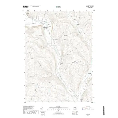
2019 Map of Candor
USGS Topo · Published 2019About this map
Catatonk Creek and Owego Creek carve prominent valleys through the high ground of central Tioga County, defining the settlement patterns seen in this 2019 survey. The village of Candor serves as a local hub, situated where Hibbard Hill Brook joins the main creek. The surrounding landscape is dotted with ancestral markers, from Maple Grove Cem in the north to the isolated Germany Hill Cem on the high southern slopes. Smaller hamlets like Hubbardtown and Fairfield are connected by a network of winding ridge roads such as Raish Hill Rd and Spaulding Hill Rd. The topographic detail reveals the sharp relief between Candor Hill and the deep valley floor at Catatonk, illustrating why the primary transportation routes and communities remained focused along the fertile bottomlands near Turners Bridge.
Find a feature on this map
95 named features on this map. Tap any name to fly to it.
Don’t see what you’re looking for? This feature index may not catch every label — zoom into the map to look around manually.
Map Details
Editions of this 2019 Candor Map
This is the sole edition of this map. No revisions or reprints were ever made.
Other maps of this area

1900 · Dryden
USGS Topo · 1:62,500

1901 · Apalachin
USGS Topo · 1:62,500

1903 · Owego
USGS Topo · 1:62,500

1903 · Harford
USGS Topo · 1:62,500

1904 · Apalachin
USGS Topo · 1:62,500

1906 · Catatonk
USGS Topo · 1:125,000

1949 · Willseyville
USGS Topo · 1:24,000

1949 · Speedsville
USGS Topo · 1:24,000

1950 · Elmira
USGS Topo · 1:250,000
1950 · Richford
USGS Topo · 1:24,000