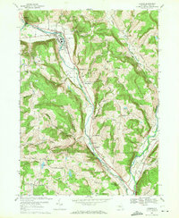
1969 Map of Candor
USGS Topo · Published 1971About this map
Catatonk Creek carves a deep valley through the Tioga County hills, serving as the primary corridor for both the Lehigh Valley Railroad and the historic settlements of Candor and Catatonk. In this late-1960s landscape, the village of Candor is clearly defined as the local hub, featuring its Central High Sch, Maple Grove Cem, and an Athletic Field. To the south, the valley floor widens near the confluence of several streams, where the County Farm and St Francis Ch stand near the southern reach of the railroad line. The surrounding uplands are marked by steep ridges and hollows, including Germany Hill and Diamond Peak, where numerous family-named roads like Logue Hill Road and Spaulding Hill Road connect isolated farms. This survey provides a detailed view of the rural infrastructure of the era, from the Gaging Sta on the creek to the Golf Course and several localized gravel pits that supported the township's development.
Find a feature on this map
68 named features on this map. Tap any name to fly to it.
Don’t see what you’re looking for? This feature index may not catch every label — zoom into the map to look around manually.
Map Details
Editions of this 1969 Candor Map
This is the sole edition of this map. No revisions or reprints were ever made.
Other maps of this area

1900 · Dryden
USGS Topo · 1:62,500

1901 · Apalachin
USGS Topo · 1:62,500

1903 · Owego
USGS Topo · 1:62,500

1903 · Harford
USGS Topo · 1:62,500

1904 · Apalachin
USGS Topo · 1:62,500

1906 · Catatonk
USGS Topo · 1:125,000

1949 · Willseyville
USGS Topo · 1:24,000

1949 · Speedsville
USGS Topo · 1:24,000

1950 · Elmira
USGS Topo · 1:250,000
1950 · Richford
USGS Topo · 1:24,000