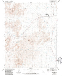
1986 Map of Cane Spring
USGS Topo · Published 1987About this map
Nevada Test Site dominates this 1980s landscape in Nye County, revealing a restricted area defined by arid valleys and high ridges. The map shows the intersection of military infrastructure and older desert landmarks, where Cane Spring Road and Mercury Highway traverse basins like Wahmonie Flat and Pluto Valley. Geological interest is centered on features such as Mount Salyer and the prominent Black Ridge.
Find a feature on this map
19 named features on this map. Tap any name to fly to it.
Don’t see what you’re looking for? This feature index may not catch every label — zoom into the map to look around manually.
Map Details
Editions of this 1986 Cane Spring Map
This is the sole edition of this map. No revisions or reprints were ever made.
Other maps of this area

1907 · Las Vegas
USGS Topo · 1:250,000

1908 · Furnace Creek
USGS Topo · 1:250,000

1908 · Las Vegas
USGS Topo · 1:250,000

1910 · Furnace Creek
USGS Topo · 1:250,000

1942 · Indian Spring
USGS Topo · 1:125,000

1942 · Skull Mountain
USGS Topo · 1:125,000

1948 · Death Valley
USGS Topo · 1:250,000

1952 · Specter Range
USGS Topo · 1:62,500

1952 · Mercury
USGS Topo · 1:62,500
1952 · Frenchman Lake
USGS Topo · 1:62,500