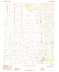
1985 Map of Cane Springs SE
USGS Topo · Published 1985About this map
The Grand Wash Cliffs dominate this 1980s landscape in Mohave County, where the high plateau gives way to a complex system of drainage and erosion. A series of deeply incised canyons and dry washes, including Pocum Canyon and Black Canyon, carve their way through the terrain toward the south. These features reveal the intricate water-carved geography of the region before more modern infrastructure altered the more remote reaches of Arizona. The presence of Grass as a terrain label suggests specific ecological zones within this arid environment, likely marking grazing areas or distinct botanical pockets. Researchers can follow the descent from the high cliffs down through the branching networks of Pocum Wash and Hidden Wash, which illustrate the natural drainage patterns that have historically dictated movement and land use in this part of the state.
Find a feature on this map
8 named features on this map. Tap any name to fly to it.
Don’t see what you’re looking for? This feature index may not catch every label — zoom into the map to look around manually.
Map Details
Editions of this 1985 Cane Springs SE Map
This is the sole edition of this map. No revisions or reprints were ever made.
Other maps of this area

1886 · Mt. Trumbull
USGS Topo · 1:250,000

1892 · Mt. Trumbull
USGS Topo · 1:250,000

1953 · Grand Canyon
USGS Topo · 1:250,000

1954 · Littlefield 3 SW
USGS Topo · 1:24,000

1954 · Littlefield 3 NE
USGS Topo · 1:24,000
1954 · Littlefield 3 SE
USGS Topo · 1:24,000

1954 · Cane Springs
USGS Topo · 1:62,500

1957 · Grand Canyon
USGS Topo · 1:250,000

1958 · Grand Canyon
USGS Topo · 1:250,000

1960 · Grand Canyon
USGS Topo · 1:250,000