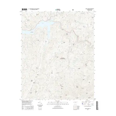
2016 Map of Caney Creek
USGS Topo · Published 2016About this map
The Ocoee River snakes through this mountainous reach of the Cherokee National Forest, feeding the expansive Lake Ocoee and its prominent Sylco Inlet. The map documents a terrain defined by sharp ridges and gaps, including the Tennessee Valley Divide and the massive Chilhowee Mtn. Small pockets of human history are preserved in the numerous family burying grounds, such as Beckler Cem, Price Cem, and Old Fairview Cem, which sit atop the ridges or near the water's edge. The settlement at Sylco remains the primary point of reference in the southern portion of the quadrangle. An intriguing engineering feature, the Ocoee Flume, traces the northern bank of the river, following the contours of the land toward Caney Creek. This detailed 2016 survey captures the balance between the managed wilderness of the national forest and the deep-rooted local genealogy of Polk County.
Find a feature on this map
96 named features on this map. Tap any name to fly to it.
Don’t see what you’re looking for? This feature index may not catch every label — zoom into the map to look around manually.
Map Details
Editions of this 2016 Caney Creek Map
This is the sole edition of this map. No revisions or reprints were ever made.
Other maps of this area

1886 · Dalton
USGS Topo · 1:125,000

1886 · Cleveland
USGS Topo · 1:125,000

1888 · Ellijay
USGS Topo · 1:125,000

1892 · Cleveland
USGS Topo · 1:125,000

1892 · Ellijay
USGS Topo · 1:125,000

1892 · Dalton
USGS Topo · 1:125,000

1893 · Murphy
USGS Topo · 1:125,000

1895 · Cleveland
USGS Topo · 1:125,000

1897 · Dalton
USGS Topo · 1:125,000

1898 · Ellijay
USGS Topo · 1:125,000