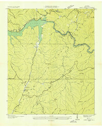
1935 Map of Caney Creek
USGS Topo · Published 1935About this map
Lake Ocoee and the Ocoee River dominate the northern landscape of this portion of the Cherokee National Forest during the mid-1930s. The Tennessee Valley Authority's industrial footprint is clearly visible through the Ocoee No 2 Power Plant, a complex system of Electric Power Company Transmission Lines, and a specialized Flume Line following the river bend. This period of federal land management and labor is highlighted by the presence of both CCC Camp No 1451 and CCC Camp No 1452, marking the Civilian Conservation Corps' role in developing the forest infrastructure.
Find a feature on this map
74 named features on this map. Tap any name to fly to it.
Don’t see what you’re looking for? This feature index may not catch every label — zoom into the map to look around manually.
Map Details
Editions of this 1935 Caney Creek Map
This is the sole edition of this map. No revisions or reprints were ever made.
Other maps of this area

1886 · Dalton
USGS Topo · 1:125,000

1886 · Cleveland
USGS Topo · 1:125,000

1888 · Ellijay
USGS Topo · 1:125,000

1892 · Cleveland
USGS Topo · 1:125,000

1892 · Ellijay
USGS Topo · 1:125,000

1892 · Dalton
USGS Topo · 1:125,000

1893 · Murphy
USGS Topo · 1:125,000

1895 · Cleveland
USGS Topo · 1:125,000

1897 · Dalton
USGS Topo · 1:125,000

1898 · Ellijay
USGS Topo · 1:125,000