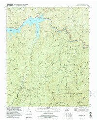
1999 Map of Caney Creek
USGS Topo · Published 2001About this map
Lake Ocoee and the winding Ocoee River dominate this portion of the Cherokee National Forest in Polk County. The landscape is defined by the industrial legacy of the Old Copper Road and the Ocoee Power Plant No 2, which highlight the region's history of resource extraction and hydroelectric development. Settlement is sparse, represented by scattered family sites like Beckler Cem and Curbow Cem, and small clearings such as Dutch Fields.
Find a feature on this map
94 named features on this map. Tap any name to fly to it.
Don’t see what you’re looking for? This feature index may not catch every label — zoom into the map to look around manually.
Map Details
Editions of this 1999 Caney Creek Map
This is the sole edition of this map. No revisions or reprints were ever made.
Other maps of this area

1886 · Dalton
USGS Topo · 1:125,000

1886 · Cleveland
USGS Topo · 1:125,000

1888 · Ellijay
USGS Topo · 1:125,000

1892 · Cleveland
USGS Topo · 1:125,000

1892 · Ellijay
USGS Topo · 1:125,000

1892 · Dalton
USGS Topo · 1:125,000

1893 · Murphy
USGS Topo · 1:125,000

1895 · Cleveland
USGS Topo · 1:125,000

1897 · Dalton
USGS Topo · 1:125,000

1898 · Ellijay
USGS Topo · 1:125,000