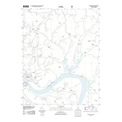
2011 Map of Cannelton
USGS Topo · Published 2011About this map
The Ohio River carves a deep bend through the heart of this landscape, separating the Indiana riverfront at Cannelton from Hawesville on the Kentucky shore. The terrain is defined by a dense network of ridges and hollows, including Coontail Ridge and Sulphur Springs Hollow, where small settlements and family cemeteries are tucked into the rising ground. Genealogists will find numerous burial sites such as Cliff Cemetery and Log Church Cemetery near the river’s edge, as well as the Saint Johns Cemetery further inland. The map shows the region's transport infrastructure, from the Lincoln Trail Bridge connecting the states to the Wescor Western Kraft Rd railroad line serving industry near Skillman. Water features like Echo Valley Lake and the Echo Valley Lake Dam suggest a landscape managed for recreation and local utility alongside the larger commerce of the river valley.
Find a feature on this map
98 named features on this map. Tap any name to fly to it.
Don’t see what you’re looking for? This feature index may not catch every label — zoom into the map to look around manually.
Map Details
Editions of this 2011 Cannelton Map
This is the sole edition of this map. No revisions or reprints were ever made.
Other maps of this area

1900 · St Meinrad
USGS Topo · 1:62,500

1903 · St. Meinrad
USGS Topo · 1:62,500

1903 · Tell City
USGS Topo · 1:62,500

1934 · Cannelton
USGS Topo · 1:62,500

1949 · Cannelton
USGS Topo · 1:24,000

1953 · Cannelton
USGS Topo · 1:24,000

1953 · Cloverport
USGS Topo · 1:24,000

1953 · Tell City
USGS Topo · 1:24,000
1953 · Mattingly
USGS Topo · 1:24,000
1953 · Rome
USGS Topo · 1:24,000