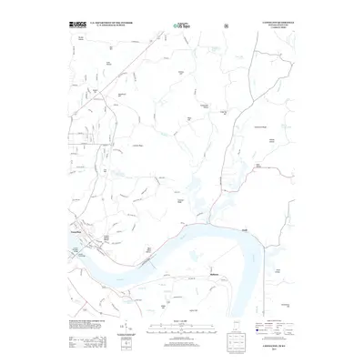
2013 Map of Cannelton
USGS Topo · Published 2013About this map
Cannelton sits at the heart of this riverfront landscape, positioned along a sharp bend of the Ohio River across from the small settlements of Skillman and Dodd. This 2013 survey illustrates the local topography of the Indiana-Kentucky border, where high ground like Lockner Ridge and Coontail Ridge divides deep drainage basins. Notable transport links include the Lincoln Toll Road Bridge and Lincoln Trail Bridge, which connect the Perry County seat to the Kentucky shore. Away from the river, the interior is marked by numerous family-named landmarks such as McCallister Hill and Lutgring Hill, reflecting the local genealogy and land-use patterns of the region. Distinctive features like Jeffry Cliff and Sulphur Springs Hollow highlight the varied terrain found between the riverbanks and the northern reaches of the quadrangle.
Find a feature on this map
126 named features on this map. Tap any name to fly to it.
Don’t see what you’re looking for? This feature index may not catch every label — zoom into the map to look around manually.
Map Details
Editions of this 2013 Cannelton Map
This is the sole edition of this map. No revisions or reprints were ever made.
Other maps of this area

1900 · St Meinrad
USGS Topo · 1:62,500

1903 · St. Meinrad
USGS Topo · 1:62,500

1903 · Tell City
USGS Topo · 1:62,500

1934 · Cannelton
USGS Topo · 1:62,500

1949 · Cannelton
USGS Topo · 1:24,000

1953 · Cannelton
USGS Topo · 1:24,000

1953 · Cloverport
USGS Topo · 1:24,000

1953 · Tell City
USGS Topo · 1:24,000
1953 · Mattingly
USGS Topo · 1:24,000
1953 · Rome
USGS Topo · 1:24,000