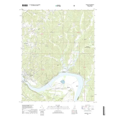
2019 Map of Cannelton
USGS Topo · Published 2019About this map
The Ohio River carves a deep horseshoe bend between Indiana and Kentucky, defining the industrial and agricultural landscape of Perry and Hancock Counties. On the northern bank, the riverfront communities of Tell City and Cannelton are linked to Hawesville by the Lincoln Trail Bridge. This corridor is dense with local history, featuring numerous burial sites such as Saint Michaels Cem and the Log Church Cem. The terrain rises sharply away from the river into the ridges of the Hoosier National Forest, where features like Lockner Ridge and Goosetown Ridge overlook the valley.
Find a feature on this map
107 named features on this map. Tap any name to fly to it.
Don’t see what you’re looking for? This feature index may not catch every label — zoom into the map to look around manually.
Map Details
Editions of this 2019 Cannelton Map
This is the sole edition of this map. No revisions or reprints were ever made.
Other maps of this area

1900 · St Meinrad
USGS Topo · 1:62,500

1903 · St. Meinrad
USGS Topo · 1:62,500

1903 · Tell City
USGS Topo · 1:62,500

1934 · Cannelton
USGS Topo · 1:62,500

1949 · Cannelton
USGS Topo · 1:24,000

1953 · Cannelton
USGS Topo · 1:24,000

1953 · Cloverport
USGS Topo · 1:24,000

1953 · Tell City
USGS Topo · 1:24,000
1953 · Mattingly
USGS Topo · 1:24,000
1953 · Rome
USGS Topo · 1:24,000