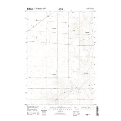
2015 Map of Canning
USGS Topo · Published 2015About this map
Canning sits at the base of a significant relief system where the prairie breaks into deep drainages and isolated high points. The terrain is defined by a series of named draws and gulches, including Brekke Draw, Dehart Draw, and Hiddenwood Gulch, which channel seasonal runoff toward the south. A prominent landmark, Medicine Knoll, rises above the surrounding landscape in the northeast, while the expansive Gumbo Flat occupies the western portion of the quadrangle. Water features are sparse but vital in this Hughes County landscape, most notably Lake Chesley and the winding course of Medicine Knoll Cr. This modern survey illustrates the persistent township and range grid system, with roads like 200th St and 207th St following property lines through the agricultural and pastoral land typical of central South Dakota.
Find a feature on this map
25 named features on this map. Tap any name to fly to it.
Don’t see what you’re looking for? This feature index may not catch every label — zoom into the map to look around manually.
Map Details
Editions of this 2015 Canning Map
This is the sole edition of this map. No revisions or reprints were ever made.
Other maps of this area

1934 · Canning
USGS Topo · 1:48,000

1937 · Canning
USGS Topo · 1:62,500

1953 · Huron
USGS Topo · 1:250,000

1954 · Pierre
USGS Topo · 1:250,000

1954 · Huron
USGS Topo · 1:250,000

1958 · Pierre
USGS Topo · 1:250,000

1967 · Canning
USGS Topo · 1:24,000

1967 · Onida SE
USGS Topo · 1:24,000

1967 · Onida SW
USGS Topo · 1:24,000
1967 · Canning NW
USGS Topo · 1:24,000