
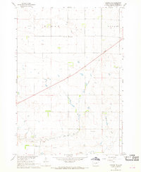
2017 Map of Canning
USGS Topo · Published 2017About this map
Medicine Knoll rises above the Hughes County landscape, a prominent geological feature in an area defined by deep draws and intermittent watercourses. The small community of Canning sits near the southern edge of the quadrangle, where Canning Road and County Road 652 intersect. Local history is anchored by the Canning Cemetery, located just west of the town center near Lake Chesley. The terrain shows a distinct drainage pattern where Medicine Knoll Creek winds through the eastern half of the map, fed by various topographic depressions such as Brekke Draw and Dehart Draw. To the northwest, the broad, low-lying expanse of Gumbo Flat illustrates the unique prairie soil characteristics of the region. This 2017 survey reflects the modern section-line road network that organizes the agricultural lands of Township 112 North, showing how modern infrastructure follows the early township and range divisions.
Find a feature on this map
32 named features on this map. Tap any name to fly to it.
Don’t see what you’re looking for? This feature index may not catch every label — zoom into the map to look around manually.
Map Details
Editions of this 2017 Canning Map
This is the sole edition of this map. No revisions or reprints were ever made.
Other maps of this area

1934 · Canning
USGS Topo · 1:48,000

1937 · Canning
USGS Topo · 1:62,500

1953 · Huron
USGS Topo · 1:250,000

1954 · Pierre
USGS Topo · 1:250,000

1954 · Huron
USGS Topo · 1:250,000

1958 · Pierre
USGS Topo · 1:250,000

1967 · Canning
USGS Topo · 1:24,000

1967 · Onida SE
USGS Topo · 1:24,000

1967 · Onida SW
USGS Topo · 1:24,000
1967 · Canning NW
USGS Topo · 1:24,000