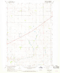
1967 Map of Canning NW
USGS Topo · Published 1968About this map
Sunnyside Sch stands as a local landmark in this central South Dakota landscape, surveyed as part of the Department of the Interior's development program for the Missouri River Basin. The terrain is defined by the ephemeral drainage of Dry Run and the winding course of Mush Creek, which carve through the townships of Byron and Logan. The most prominent human alteration to the landscape is the diagonal path of an Old Railroad Grade, tracing a defunct transportation route that once connected these rural prairie townships. Modern infrastructure of the late 1960s is represented by a Radio Facility and Radio Tower, while industrial activity is localized at several Gravel Pits. This sheet provides a clear view of the sparse settlement patterns and the transition from rail-dependent commerce to a landscape increasingly marked by communication and field lines.
Find a feature on this map
12 named features on this map. Tap any name to fly to it.
Don’t see what you’re looking for? This feature index may not catch every label — zoom into the map to look around manually.
Map Details
Editions of this 1967 Canning NW Map
This is the sole edition of this map. No revisions or reprints were ever made.
Other maps of this area

1924 · Pierre
USGS Topo · 1:62,500

1934 · Canning
USGS Topo · 1:48,000

1937 · Canning
USGS Topo · 1:62,500

1954 · Pierre
USGS Topo · 1:250,000

1958 · Pierre
USGS Topo · 1:250,000

1967 · Pierre NE
USGS Topo · 1:24,000

1967 · Canning
USGS Topo · 1:24,000

1967 · Onida SE
USGS Topo · 1:24,000

1967 · Onida SW
USGS Topo · 1:24,000
1967 · Okobojo SE
USGS Topo · 1:24,000