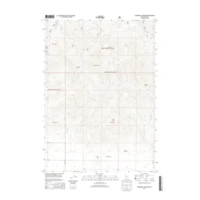
2013 Map of Cannonball Mountain
USGS Topo · Published 2013About this map
Sawtooth National Forest encompasses the majority of this high-elevation terrain, where the peaks of the Soldier Mountains dominate the central landscape. The geography is defined by a series of steep drainage basins, including Cannonball Cr and Elk Cr, which flow south toward the northern edge of the Camas Prarie. This map captures a transition from the alpine heights of Cannonball Mtn and Liberal Mtn to the flatter ranching lands along the southern border. Notable landmarks for those navigating the backcountry include the Elk Creek Hot Spring and Wells Summit, alongside numerous named canyons such as Mill Canyon and McDonald Gulch. The road network is sparse, primarily consisting of forest access routes like Peck Rd and Davidson Rd that trace the lowlands beneath Cline Hill.
Find a feature on this map
43 named features on this map. Tap any name to fly to it.
Don’t see what you’re looking for? This feature index may not catch every label — zoom into the map to look around manually.
Map Details
Editions of this 2013 Cannonball Mountain Map
This is the sole edition of this map. No revisions or reprints were ever made.
Other maps of this area

1900 · Sawtooth
USGS Topo · 1:125,000

1955 · Hailey
USGS Topo · 1:250,000

1957 · Fairfield
USGS Topo · 1:62,500

1957 · Blaine
USGS Topo · 1:62,500

1959 · Hailey
USGS Topo · 1:250,000

1962 · Hailey
USGS Topo · 1:250,000

1970 · Sydney Butte
USGS Topo · 1:24,000

1970 · Dollarhide Mtn
USGS Topo · 1:24,000
1970 · Buttercup Mtn
USGS Topo · 1:24,000
1986 · Phillips
USGS Topo · 1:24,000