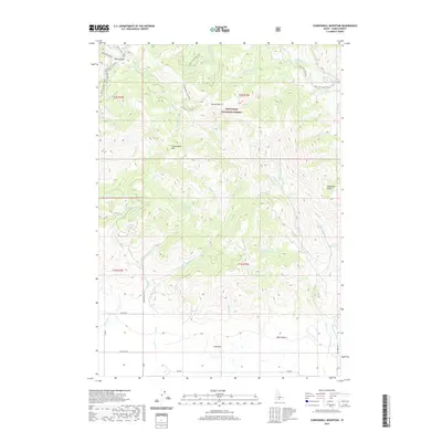
2020 Map of Cannonball Mountain
USGS Topo · Published 2020About this map
The Sawtooth National Forest dominates this section of the Idaho backcountry, where the landscape is defined by the high elevations of Cannonball Mtn and Liberal Mtn. This high-country drainage network feeds into several forks of the Elk Creek, most notably at the Elk Creek Hot Spring located in the eastern portion of the quadrangle. The map reveals a specialized transportation network adapted for the high terrain, featuring the Camp Creek Jeep Trail, Liberal Loop Jeep Trail, and Ditto Flat Jeep Trail which provide access across the ridge lines.
Find a feature on this map
49 named features on this map. Tap any name to fly to it.
Don’t see what you’re looking for? This feature index may not catch every label — zoom into the map to look around manually.
Map Details
Editions of this 2020 Cannonball Mountain Map
This is the sole edition of this map. No revisions or reprints were ever made.
Other maps of this area

1900 · Sawtooth
USGS Topo · 1:125,000

1955 · Hailey
USGS Topo · 1:250,000

1957 · Fairfield
USGS Topo · 1:62,500

1957 · Blaine
USGS Topo · 1:62,500

1959 · Hailey
USGS Topo · 1:250,000

1962 · Hailey
USGS Topo · 1:250,000

1970 · Sydney Butte
USGS Topo · 1:24,000

1970 · Dollarhide Mtn
USGS Topo · 1:24,000
1970 · Buttercup Mtn
USGS Topo · 1:24,000
1986 · Phillips
USGS Topo · 1:24,000