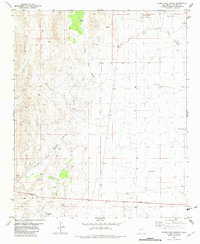
1981 Map of Canon Agua Buena
USGS Topo · Published 1982About this map
The coal mining legacy of Socorro County is clearly etched into the landscape of the Blackington Hills and surrounding canyons. This early 1980s record captures the industrial transition of the area, featuring the historical footprint of Carthage and the nearby Old Carthage (Site). These settlements grew around the coal deposits that once fueled the regional railroads, an era represented here by the Old Railroad Grade and numerous scattered Mines, including the Hart Mine and Law Mine.
Find a feature on this map
25 named features on this map. Tap any name to fly to it.
Don’t see what you’re looking for? This feature index may not catch every label — zoom into the map to look around manually.
Map Details
Editions of this 1981 Canon Agua Buena Map
This is the sole edition of this map. No revisions or reprints were ever made.
Other maps of this area

1906 · Socorro
USGS Topo · 1:62,500

1916 · La Joya
USGS Topo · 1:125,000

1948 · Carthage
USGS Topo · 1:62,500

1948 · San Antonio
USGS Topo · 1:62,500

1954 · Tularosa
USGS Topo · 1:250,000

1954 · Socorro
USGS Topo · 1:250,000

1958 · Socorro
USGS Topo · 1:250,000

1958 · Tularosa
USGS Topo · 1:250,000

1959 · Loma De Las Canas
USGS Topo · 1:24,000

1959 · Socorro
USGS Topo · 1:62,500