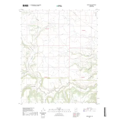
2023 Map of Canon Ancho
USGS Topo · Published 2023About this map
The Mora River carves through this high-altitude landscape along the border of Mora and San Miguel counties. The terrain is defined by an intricate network of drainage systems, including the namesake Cañon Ancho and Mexican Canyon. Human activity is primarily limited to rural infrastructure, with State Hwy 271 crossing the northern reaches and Co Rd 32 Canyon Ancho providing access to the interior. The map reveals the intersection of Spanish-named land features like Cañon Escondido and Cañon Vegocito with standard American survey parcels. Water is the primary architect of the region, visible in the winding paths of Chavez Creek, Tata Vique, and Wilcox Draw, which have historically dictated travel and ranching boundaries in this part of northern New Mexico.
Find a feature on this map
25 named features on this map. Tap any name to fly to it.
Don’t see what you’re looking for? This feature index may not catch every label — zoom into the map to look around manually.
Map Details
Editions of this 2023 Canon Ancho Map
This is the sole edition of this map. No revisions or reprints were ever made.
Other maps of this area

1892 · Watrous
USGS Topo · 1:125,000

1894 · Watrous
USGS Topo · 1:125,000

1954 · Santa Fe
USGS Topo · 1:250,000

1958 · Santa Fe
USGS Topo · 1:250,000

1964 · Frutosa Lake
USGS Topo · 1:24,000

1964 · Mogote Hills
USGS Topo · 1:24,000

1964 · Alamosa Creek
USGS Topo · 1:24,000

1964 · Canon Ancho
USGS Topo · 1:24,000

1971 · Alamito
USGS Topo · 1:24,000

1971 · Canon Las Cuevas
USGS Topo · 1:24,000