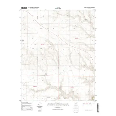
2013 Map of Canon Las Cuevas
USGS Topo · Published 2013About this map
Thompson Windmill stands as a lonely marker of ranching activity in this high-desert landscape on the border of Harding and Mora Counties. The terrain is defined by an intricate network of deep arroyos and canyons, including the significant Bootleg Canyon and Cañon Azul, which feed into the ephemeral Beaver Cr and Carrizo Cr. The cattle-country heritage is evident in the naming of geographic features after local families or historical figures, such as Cañon Juan Maestas and Cañon Leon. A primary thoroughfare, Miles Canyon Rd, provides access across the northern sections of the township, while the Cuernudo Hills rise above the complex drainages of the Cañon la Ciruela. This survey illustrates the rugged water-management and grazing geography of the New Mexico plains as it remained in the early 21st century.
Find a feature on this map
27 named features on this map. Tap any name to fly to it.
Don’t see what you’re looking for? This feature index may not catch every label — zoom into the map to look around manually.
Map Details
Editions of this 2013 Canon Las Cuevas Map
This is the sole edition of this map. No revisions or reprints were ever made.
Other maps of this area

1892 · Watrous
USGS Topo · 1:125,000

1894 · Watrous
USGS Topo · 1:125,000

1954 · Santa Fe
USGS Topo · 1:250,000

1954 · Raton
USGS Topo · 1:250,000

1958 · Raton
USGS Topo · 1:250,000

1958 · Santa Fe
USGS Topo · 1:250,000

1964 · Alto De Hormiga
USGS Topo · 1:24,000

1964 · Alamosa Creek
USGS Topo · 1:24,000

1964 · Canon Ancho
USGS Topo · 1:24,000

1971 · Beaver Canyon
USGS Topo · 1:24,000