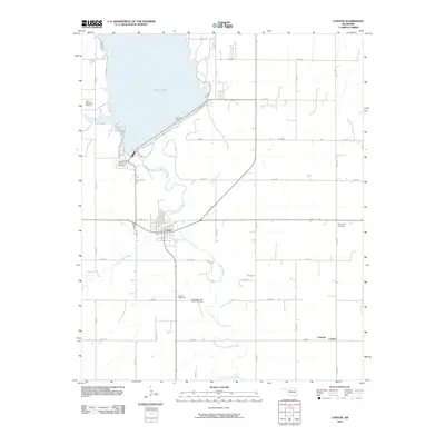
2010 Map of Canton
USGS Topo · Published 2010About this map
Canton Lake dominates the northern landscape of this Oklahoma quadrangle, held back by the prominent Canton Dam along the North Canadian River. The town of Canton sits south of the reservoir, serving as a hub where the river meets Minnehaha Creek. The map reveals a high density of culturally significant sites, particularly cemeteries that reflect the area's complex heritage, including the Indian-Mennonite Cemetery, the Zion Mennonite Indian Cemetery, and the Cantonment Reinterment Cemetery. To the southeast, the small settlements of Carleton and Carlton are situated near the meandering river banks, while a grid of section-line roads like n2520 RD and e0670 RD organizes the surrounding agricultural plains.
Find a feature on this map
32 named features on this map. Tap any name to fly to it.
Don’t see what you’re looking for? This feature index may not catch every label — zoom into the map to look around manually.
Map Details
Editions of this 2010 Canton Map
This is the sole edition of this map. No revisions or reprints were ever made.
Other maps of this area

1955 · Clinton
USGS Topo · 1:250,000

1955 · Woodward
USGS Topo · 1:250,000

1957 · Clinton
USGS Topo · 1:250,000

1958 · Woodward
USGS Topo · 1:250,000

1964 · Oakwood
USGS Topo · 1:62,500

1972 · Longdale
USGS Topo · 1:24,000

1972 · Canton NW
USGS Topo · 1:24,000

1972 · Canton
USGS Topo · 1:24,000

1972 · Canton SW
USGS Topo · 1:24,000

1972 · Southard
USGS Topo · 1:24,000