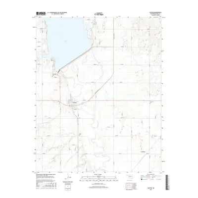
2016 Map of Canton
USGS Topo · Published 2016About this map
Canton Lake dominates the northwestern landscape of this region, serving as a primary water source and geographical anchor for the surrounding plains. The North Canadian River flows southeastward from the dam, winding through a network of section roads and agricultural lands. The town of Canton is situated near the center of the map, organized around a grid featuring W Pine St and N Grant Ave, while the smaller settlement of Carleton lies to the southeast. For local historians and genealogists, this survey is particularly valuable for its documentation of significant burial sites, including the Cantonment Reinterment Cem near the lake's edge, as well as the Canton Cem and Cherryvale Cem. These sites, along with the course of Minnehaha Cr, reflect the deep layering of settlement and natural history in this portion of Oklahoma.
Find a feature on this map
44 named features on this map. Tap any name to fly to it.
Don’t see what you’re looking for? This feature index may not catch every label — zoom into the map to look around manually.
Map Details
Editions of this 2016 Canton Map
This is the sole edition of this map. No revisions or reprints were ever made.
Other maps of this area

1955 · Clinton
USGS Topo · 1:250,000

1955 · Woodward
USGS Topo · 1:250,000

1957 · Clinton
USGS Topo · 1:250,000

1958 · Woodward
USGS Topo · 1:250,000

1964 · Oakwood
USGS Topo · 1:62,500

1972 · Longdale
USGS Topo · 1:24,000

1972 · Canton NW
USGS Topo · 1:24,000

1972 · Canton
USGS Topo · 1:24,000

1972 · Canton SW
USGS Topo · 1:24,000

1972 · Southard
USGS Topo · 1:24,000