
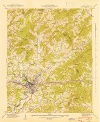
1942 Map of Canton
USGS Topo · Published 1942About this map
Industrial and agricultural life in Haywood County converges at Canton, where the Pigeon River and the Southern railroad define the local geography. This 1941 field examination captures the town during a period of wartime productivity, notably featuring the Fiberville district and West Canton. Beyond the industrial center, the landscape transitions into a series of high ridges and deep coves, including Newfound Mountain and Leicester Mountain. Rural community life is anchored by numerous small landmarks such as Browns Chapel, Beaverdam School, and Liberty Church. The map documents the intricate drainage network of Hominy Creek and Beaverdam Creek, while the southern reaches extend into the protected lands of the Pisgah National Forest. Genealogists will find significant value in the detailed placement of family-named features like Clark Cem and Henderson Cem located near the established Turnpike route.
Find a feature on this map
104 named features on this map. Tap any name to fly to it.
Don’t see what you’re looking for? This feature index may not catch every label — zoom into the map to look around manually.
Map Details
Editions of this 1942 Canton Map
2 editions found
Other maps of this area

1894 · Asheville
USGS Topo · 1:125,000

1901 · Asheville
USGS Topo · 1:125,000

1905 · Pisgah
USGS Topo · 1:125,000

1906 · Pisgah
USGS Topo · 1:125,000

1935 · Cruso
USGS Topo · 1:24,000

1935 · Waynesville
USGS Topo · 1:24,000

1935 · Canton
USGS Topo · 1:24,000

1935 · Clyde
USGS Topo · 1:24,000

1936 · Sandymush
USGS Topo · 1:24,000

1936 · Enka
USGS Topo · 1:24,000