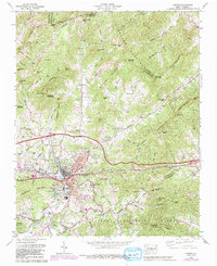
1967 Map of Canton
USGS Topo · Published 1991About this map
Industrial development along the Pigeon River anchors this study of Haywood County, where the town of Canton and its mill-adjacent neighborhood of Fibreville represent a significant mid-century manufacturing hub. The map illustrates the town's infrastructure in detail, including the Southern railroad line, a large filtration plant, and various settling tanks necessary for the local paper and fiber industries. Surrounding the urban center, the landscape transitions into the steep slopes of Newfound Mountain and Anderson Mountain, where residential growth is shown in new developments like Port Farm Addition.
Find a feature on this map
111 named features on this map. Tap any name to fly to it.
Don’t see what you’re looking for? This feature index may not catch every label — zoom into the map to look around manually.
Map Details
Editions of this 1967 Canton Map
4 editions found
Other maps of this area

1894 · Asheville
USGS Topo · 1:125,000

1901 · Asheville
USGS Topo · 1:125,000

1905 · Pisgah
USGS Topo · 1:125,000

1906 · Pisgah
USGS Topo · 1:125,000

1935 · Cruso
USGS Topo · 1:24,000

1935 · Waynesville
USGS Topo · 1:24,000

1935 · Canton
USGS Topo · 1:24,000

1935 · Clyde
USGS Topo · 1:24,000

1936 · Sandymush
USGS Topo · 1:24,000

1936 · Enka
USGS Topo · 1:24,000