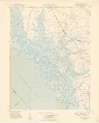
1949 Map of Canton
USGS Topo · Published 1949About this map
Lower Alloways Creek and the tidal salt marshes of the Delaware Bay shoreline dominate this mid-century coastal survey. The landscape is defined by an intricate network of waterways, including Mad Horse Creek and Stow Creek, which snake through expansive wetlands like Newport Meadows and Grandad Meadows. Small farming and fishing hamlets are scattered along the higher ground, notably Canton, Harmersville, and Garrison Corner.
Find a feature on this map
60 named features on this map. Tap any name to fly to it.
Don’t see what you’re looking for? This feature index may not catch every label — zoom into the map to look around manually.
Map Details
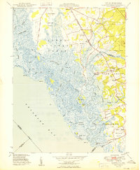
Editions of this 1949 Canton Map
2 editions found
Other maps of this area

1890 · Salem
USGS Topo · 1:62,500

1890 · Bay Side
USGS Topo · 1:62,500

1894 · Bay Side
USGS Topo · 1:62,500

1898 · Salem
USGS Topo · 1:62,500

1899 · Vineland
USGS Topo · 1:125,000

1899 · Dover
USGS Topo · 1:125,000

1901 · Camden
USGS Topo · 1:125,000

1904 · Wilmington
USGS Topo · 1:62,500

1906 · Dover
USGS Topo · 1:125,000

1906 · Wilmington
USGS Topo · 1:62,500
Featured Places
- Quinton Township, NJ
- Lower Alloways Creek Township, NJ
- Greenwich Township, NJ
- Garrison Corner, Stow Creek Township
- Willis Corner, Stow Creek Township