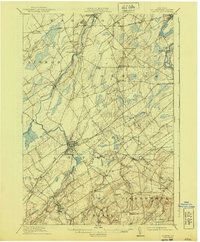
1911 Map of Canton
USGS Topo · Published 1940About this map
Canton serves as the focal point of this northern New York landscape, situated at the confluence of several early transportation routes. The Grass River and Raquette River dominate the drainage patterns, supporting small riverside hamlets like Morley and Hewittville. The rail network of the early twentieth century is well-defined, showing the Rutland Railroad cutting across the northern reaches while the New York Central Railroad connects Eddy and Pyrites to the regional hub.
Find a feature on this map
46 named features on this map. Tap any name to fly to it.
Don’t see what you’re looking for? This feature index may not catch every label — zoom into the map to look around manually.
Map Details
Editions of this 1911 Canton Map
4 editions found
Other maps of this area

1904 · Lisbon
USGS Topo · 1:48,000

1904 · Ogdensburg
USGS Topo · 1:62,500

1905 · Waddington
USGS Topo · 1:62,500

1905 · Ogdensburg
USGS Topo · 1:62,500

1906 · Red Mills
USGS Topo · 1:62,500

1906 · Massena
USGS Topo · 1:62,500

1907 · Massena
USGS Topo · 1:62,500

1908 · Potsdam
USGS Topo · 1:62,500

1910 · Canton
USGS Topo · 1:62,500

1911 · Canton
USGS Topo · 1:62,500