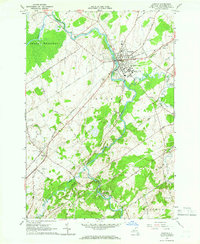
1964 Map of Canton
USGS Topo · Published 1966About this map
The village of Canton serves as the hub of this mid-1960s landscape, characterized by the winding path of the Grass River and the meeting of academic and agricultural life. Educational landmarks such as St Lawrence University and the State Agr and Tech Institute are prominent on the village outskirts, while the New York Central railroad corridor connects the central settlement to outlying points like Eddy and the industrial station at Pyrites.
Find a feature on this map
64 named features on this map. Tap any name to fly to it.
Don’t see what you’re looking for? This feature index may not catch every label — zoom into the map to look around manually.
Map Details
Editions of this 1964 Canton Map
2 editions found
Other maps of this area

1904 · Ogdensburg
USGS Topo · 1:62,500

1905 · Ogdensburg
USGS Topo · 1:62,500

1910 · Canton
USGS Topo · 1:62,500

1911 · Canton
USGS Topo · 1:62,500

1915 · Gouverneur
USGS Topo · 1:62,500

1915 · Russell
USGS Topo · 1:62,500

1918 · Russell
USGS Topo · 1:62,500

1937 · Gouverneur
USGS Topo · 1:62,500

1943 · Rensselaer Falls
USGS Topo · 1:31,680

1943 · Lisbon
USGS Topo · 1:31,680