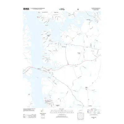
2013 Map of Canton
USGS Topo · Published 2013About this map
Canton serves as a central hub on the eastern shores of Lake Barkley in this modern topographical study. The shoreline is characterized by numerous residential developments such as Rockcastle Shores, Shawnee Hills, and Barkley Shores, reflecting the mid-to-late 20th-century transformation of this region into a recreation-centered landscape. Despite this growth, many older landmarks persist, including the Trigg Furnace site and a significant network of family and local burial grounds like Liberty Point Cem, Jefferson Cem, and Carr Cem. The map detail traces the winding course of Blue Spring Cr and Hopson Cr, while the Lake Barkley State Park Airport occupies a prominent position near the spring-fed waters of Blue Spring. This intersection of traditional rural settlements like Maple Grove and modern lakefront communities provides a detailed look at the evolving geography of Trigg County.
Find a feature on this map
145 named features on this map. Tap any name to fly to it.
Don’t see what you’re looking for? This feature index may not catch every label — zoom into the map to look around manually.
Map Details
Editions of this 2013 Canton Map
This is the sole edition of this map. No revisions or reprints were ever made.
Other maps of this area

1936 · Mont
USGS Topo · 1:24,000

1936 · Fenton
USGS Topo · 1:24,000

1936 · Golden Pond
USGS Topo · 1:48,000

1936 · Rushing
USGS Topo · 1:24,000

1950 · Rushing Creek
USGS Topo · 1:24,000
1950 · Mont
USGS Topo · 1:24,000
1950 · Fenton
USGS Topo · 1:24,000

1951 · Model
USGS Topo · 1:24,000

1951 · Johnson Hollow
USGS Topo · 1:24,000

1953 · Canton
USGS Topo · 1:24,000