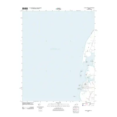
2011 Map of Cape Charles
USGS Topo · Published 2011About this map
The town of Cape Charles anchors this coastal survey, situated on the Delmarva Peninsula's southern edge where it meets the Chesapeake Bay. The map highlights the town's dense street grid and critical maritime infrastructure, including the Cape Charles Post Office and the protective North Jetty Light at the harbor entrance. Navigational markers like Cherrystone Bar Light and Cherrystone Channel Light 13 delineate the safe passage for vessels through the Cape Charles Harbor Channel. Beyond the town center, the landscape transitions into a series of inlets and points. Local geography is defined by family-named landmarks such as Savage Neck and Wescoat Point, alongside smaller settlements like Owens Landing. Water bodies like Cherrystone Inlet, Mill Creek, and Kings Creek carve into the shoreline, creating a complex interface of land and sea that has long supported the region's maritime economy.
Find a feature on this map
24 named features on this map. Tap any name to fly to it.
Don’t see what you’re looking for? This feature index may not catch every label — zoom into the map to look around manually.
Map Details
Editions of this 2011 Cape Charles Map
This is the sole edition of this map. No revisions or reprints were ever made.
Other maps of this area

1942 · Cheriton
USGS Topo · 1:24,000

1943 · Elliots Creek
USGS Topo · 1:25,000

1943 · Townsend
USGS Topo · 1:24,000

1943 · Franktown
USGS Topo · 1:31,680

1943 · Richmond
USGS Topo · 1:250,000

1946 · Eastville
USGS Topo · 1:250,000

1948 · Cape Charles
USGS Topo · 1:24,000

1949 · Richmond
USGS Topo · 1:250,000
1955 · Elliotts Creek
USGS Topo · 1:24,000
1955 · Cape Charles
USGS Topo · 1:24,000