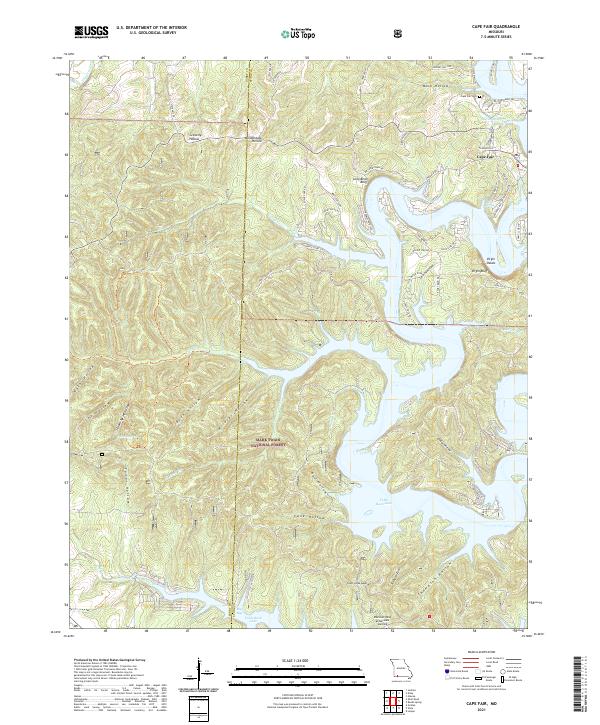
2021 Map of Cape Fair
USGS Topo · Published 2021About this map
Table Rock Lake dominates the southern half of this Stone County landscape, where the inundated valleys of Flat Creek and Piney Creek create a complex shoreline within the Mark Twain National Forest. The village of Cape Fair is situated near the northern reach of the lake, adjacent to Marsh Spring and the Cape Fair Cem. The topography is defined by numerous hollows and ridges, with named features like Gravelly Hollow and Wildcat Hollow leading down toward the water. Dramatic geological formations such as Long Bend Bluff and Virgin Bluff overlook the winding lake channels, marking the transition from upland forest to the reservoir's edge. At the southern border, Discovery Bay at Norwalk Landing indicates the continued development of the shoreline for recreation and residence, while interior landmarks like Carr Low Gap provide glimpses into the historic overland routes used before the valley was flooded.
Find a feature on this map
70 named features on this map. Tap any name to fly to it.
Don’t see what you’re looking for? This feature index may not catch every label — zoom into the map to look around manually.
Map Details
Editions of this 2021 Cape Fair Map
This is the sole edition of this map. No revisions or reprints were ever made.
Other maps of this area

1907 · Forsyth
USGS Topo · 1:125,000

1927 · Shell Knob
USGS Topo · 1:62,500

1942 · Aurora
USGS Topo · 1:62,500

1945 · Harrison
USGS Topo · 1:250,000

1945 · Aurora
USGS Topo · 1:62,500

1949 · Harrison
USGS Topo · 1:250,000

1950 · Shell Knob
USGS Topo · 1:62,500

1954 · Harrison
USGS Topo · 1:250,000

1956 · Lampe
USGS Topo · 1:24,000
1956 · Reeds Spring
USGS Topo · 1:24,000