
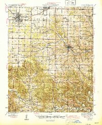
1945 Map of Aurora
USGS Topo · Published 1945About this map
Aurora and Marionville anchor the northern landscape of this Missouri Ozarks region, where the St Louis San Francisco RR and Missouri Pacific RR converge at a critical transportation junction. The map illustrates a densely settled rural network of family-centered landmarks, including numerous country schools like Liberty Sch and White Oak Sch, alongside local spiritual hubs such as Union Grove Ch and Shiloh Ch. The terrain transitions from the open stretches of Buck Prairie into a labyrinth of ridges and valleys carved by Crane Creek and Flat Creek.
Find a feature on this map
98 named features on this map. Tap any name to fly to it.
Don’t see what you’re looking for? This feature index may not catch every label — zoom into the map to look around manually.
Map Details
Editions of this 1945 Aurora Map
2 editions found
Other maps of this area

1884 · Springfield
USGS Topo · 1:125,000

1886 · Greenfield
USGS Topo · 1:125,000

1886 · Springfield
USGS Topo · 1:125,000

1888 · Greenfield
USGS Topo · 1:125,000

1907 · Forsyth
USGS Topo · 1:125,000

1919 · Halltown
USGS Topo · 1:62,500

1921 · Stotts City
USGS Topo · 1:62,500

1927 · Shell Knob
USGS Topo · 1:62,500

1937 · Cassville
USGS Topo · 1:48,000

1942 · Aurora
USGS Topo · 1:62,500